Capustan
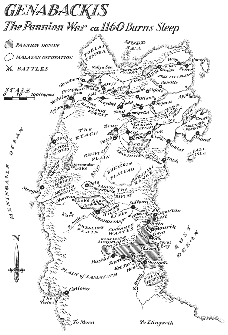
Genabackis at the time of the Pannion War

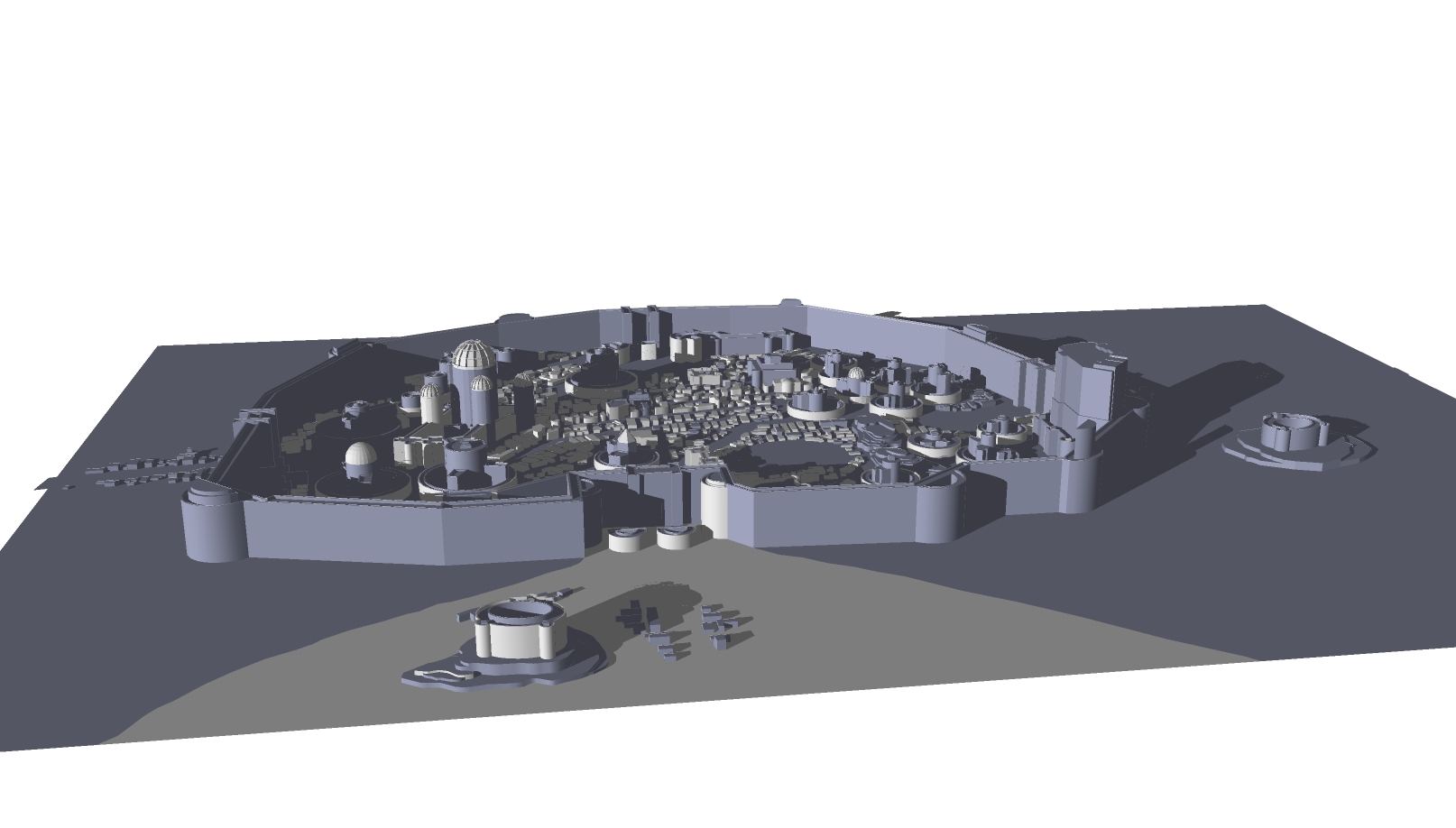
Capustan model by Corporal Nobbs aka Luktarig
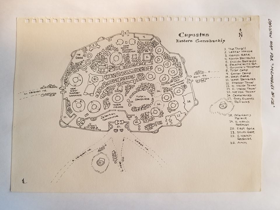
Steven Erikson's hand drawn map of Capustan
Capustan [CAP-oo-stan][1] was a small city on the north side of the river Catlin[2] in the eastern region of Genabackis near the Rust Ocean. The ancient city was founded by the once nomadic Capan tribes on lands that had been an ancestral Barghast burial ground. The Capan tribes gathered in the area for trade and eventually become sedentary.[3][4]
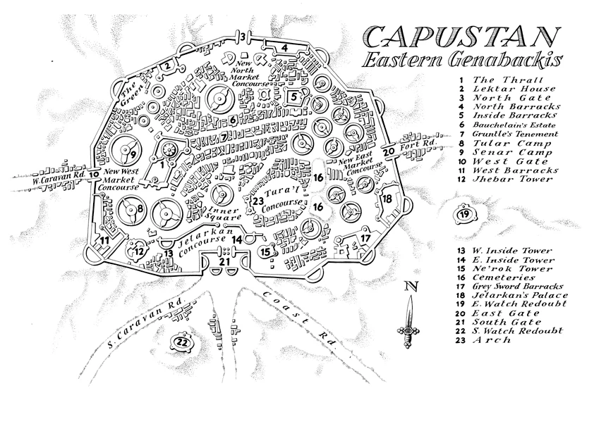
Layout[]
The city itself was divided into districts known as Camps. These camps were distinct, self-contained settlements, usually circular, with a private open area at the central hub.[3] Their residents were kin-bound by blood and marriage.[5] Itkovian thought them remnants of the original tribal encampments. They were divided from each other by by wide uneven spaces which were treated as streets. The only area which did not conform to this layout was the Temple District. It was located at the centre of Capustan surrounding the Thrall, an old Daru keep now home to the Mask Council, and maintained a Daru-style grid layout.[3]
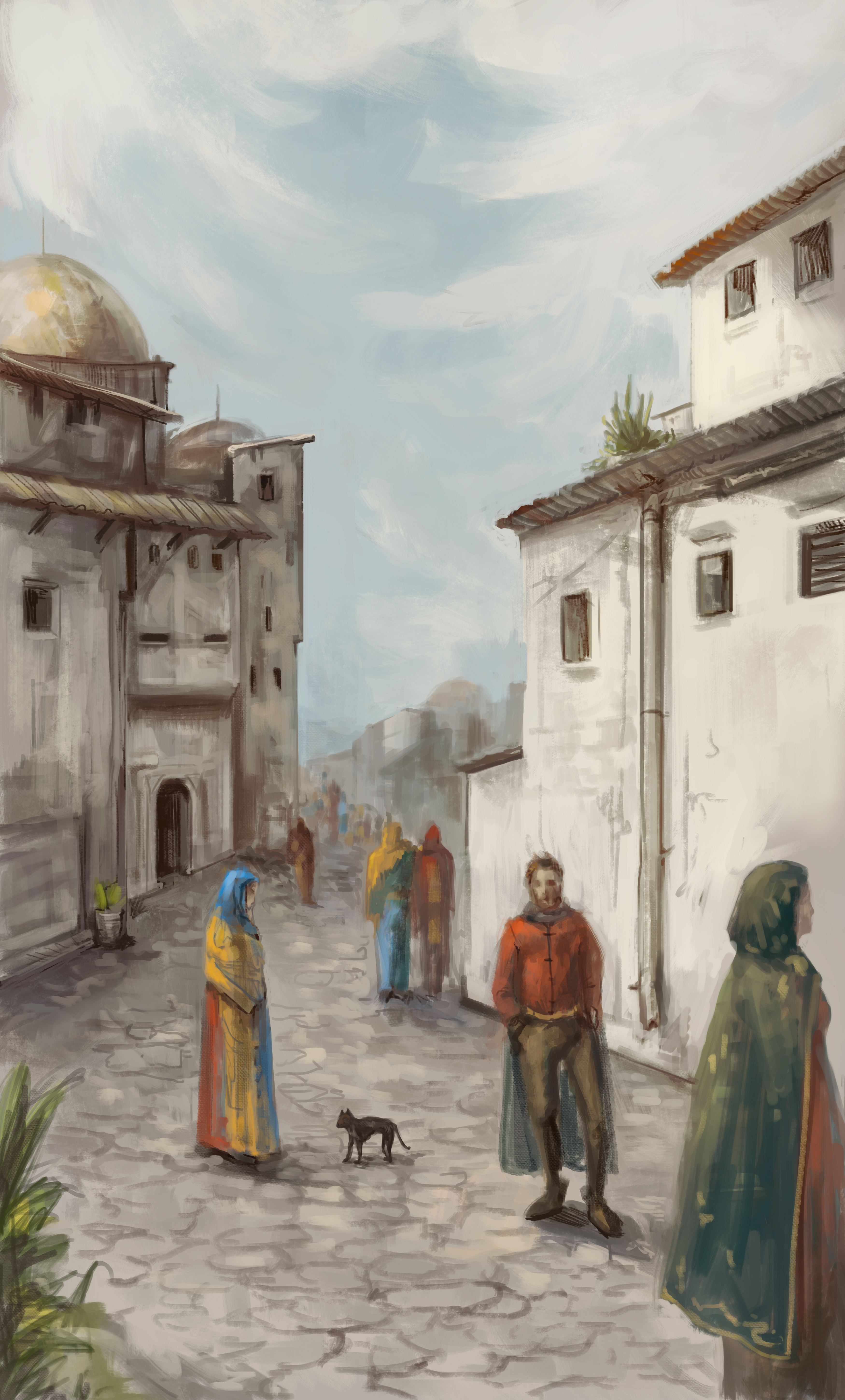
The city's architecture was plain and unpainted. It was said that the beauty of Capustan lay in its people, the Capans who wore the bright colours of their kin and the latter arriving Daru who clung to their own styles and ornamentation.[3]
Two of Capustan's largest buildings predated the city's founding and had been built by unknown hands. An ancient thick-walled keep against the city's southeast wall had been abandoned for nearly a century before being used as a barracks for the Grey Swords mercenaries.
Overshadowing it nearby was Jelarkan's Palace, ancestral home to the city's princes. It was an alien structure built of grey stone in a confusing collection of chaotic planes, angles, and overhangs. Its thin unprotected walls, lack of windows or flat rooftops, and single entrance gate made it a poor defensive fortification. But its imposing presence made it attractive as a symbol of rule. Generations of princes had added some protective features, such as guardhouses near the entrance, but the walls were too weak to be added to. The stone of the palace itself rejected attempts to take mortar resulting in the collapse of additions.[3]
The city was surrounded by mortarless walls of weathered stone topped by merloned battlements. Four gates provided entrance to the city in cardinal directions. The southern and eastern approaches to the city were guarded by two fortified brick redoubts, East Watch and South Watch, placed on low hills.[3]
The Mask Council[]
See also: Mask Council
The Mask Council was a council of High Priests and Priestesses representing the temples of the fourteen Ascendants in Capustan.[6] Each temple maintained its own private company of well-trained and well-equipped soldiers, known as the Gidrath, numbering 3000 in total.[7] The Council was based in the Thrall.
Funerary customs[]
The Capan buried their dead upright in sun-fired mud columns inscribed with spiral incisions. The effect resembled a forest and was meant to allow freedom of movement to the spirits of the once nomadic people. The Daru cremated their dead and placed them in stone urns.[3]

Capustan model by Corporal Nobbs
Attitudes towards women[]

Capustan by Anna Ploscost
Women were prohibited from the art of war and were not accepted within the city's fighting forces. Additionally, second- and third-born daughters were often discarded and cast into the streets to fend for themselves.[3]
Important people in Capustan[]
- Arard - displaced prince of Coral
- Brukhalian - Mortal Sword of Fener's Reve (The Grey Swords)
- Gruntle - caravan guard
- Itkovian - Shield Anvil of Fener's Reve (The Grey Swords)
- Jelarkan - Prince and ruler of Capustan
- Karnadas - Destriant of Fener's Reve (The Grey Swords)
- Keruli - merchant
- Mask Council
Camps and Districts[]
- Daru District[8]
- Nildar Camp[9]
- North Temple District[8]
- Senar Camp
- Temple District[10]
- Tular Camp
- Uldan[8] / Ulden[8] Camp
Notable locations[]
- Arch[11]
- Bauchelain's estate
- Daru House[12]
- East Gate (or Port Road Gate)[13]
- East Inside Tower
- East Watch Redoubt
- Grey Sword Barracks
- Gruntle's tenement
- Inside Barracks
- Jelarkan's Palace
- Jhebar Tower
- Keruli's home
- Lektar House (or Lestari House)[14]
- Ne'ror Tower (or Ne'rok Tower)[9]
- North Barracks
- North Gate
- Port Road Gate (or East Gate)[13]
- South Gate (or Main Gate)[9]
- South Watch Redoubt
- The Thrall
- West Barracks
- West Gate
- West Inside Tower
Streets and Concourses[]
- Calmanark Alley[8]
- Daru Spear[8]
- Daru Street[8]
- Inner Square
- Inside Port Street[8]
- Jelarkan Concourse
- Kilsban Way[8]
- New East Market Concourse
- New North Market Concourse
- New West Market Concourse
- Old Daru Street[8]
- Shadows Street[8]
- Tular Concourse[8]
- Tura'l Concourse
In Memories of Ice[]
The Pannion War[]
See also: Siege of Capustan

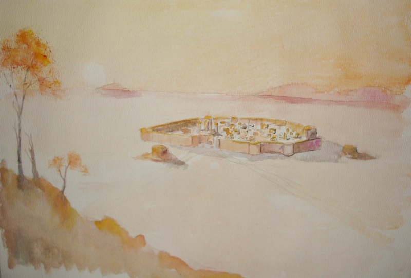
Capustan (watercolour) by Corporal Nobbs
In the 1164th year of Burn's Sleep, the advancing Pannion Domin threatened to engulf Capustan. Conflict between the city's ruling factions led to a disorganised response.[15] Prince Jelarkan supplemented the town's meagre defences by hiring 7000 Grey Sword mercenaries. The Grey Swords knew they could not defeat Septarch Kulpath's vastly larger Pannion army, but they hoped to make the effort to capture the city too costly to complete.[16]
Malazan High Fist Dujek Onearm, Caladan Brood, and Humbrall Taur of the White Face Barghast formed a fragile alliance to help save the 'doomed' city. But the Pannion forces were too overwhelming, and the city fell in three days.[17] Prince Jelarkan was captured and killed and the Grey Swords were all but wiped out.[18]
When the Malazan alliance arrived, they lifted the siege and defeated Kulpath's army, but the city was largely burned and destroyed.[19] About twenty thousand citizens survived by hiding in secret tunnels prepared by the Grey Swords.[20] As the price for Humbrall Taur's assistance, the Mask Council returned the bones of the Barghast Founding Families that had been collected from the area's original barrows.[21]
The Mask Council chose Prince Arard of Coral to replace the late Prince Jelarkan.[22]
Trivia[]
- The map included with Memories of Ice names the road leading out of the East Gate as Fort Road. But the text of the novel refers to it as Port Road.[23] When Steven Erikson released his hand drawn map of the city, it used the name Port Road, indicating the book's map is in error.
- Erikson's hand drawn map of Capustan places Bauchelain's estate further to the east than shown on the map in Memories of Ice.
Notes and references[]
- ↑ Steven Erikson Deadhouse Gates Interview - Ten Very Big Books podcast - As pronounced by Steven Erikson at 45:16
- ↑ Memories of Ice, Glossary, UK MMPB p.1183
- ↑ 3.0 3.1 3.2 3.3 3.4 3.5 3.6 3.7 Memories of Ice, Chapter 7
- ↑ Memories of Ice, Chapter 10, US SFBC p.356-352
- ↑ Memories of Ice, Chapter 10, US SFBC p.351
- ↑ Memories of Ice, Glossary, UK MMPB p.1181
- ↑ Memories of Ice, Chapter 3
- ↑ 8.00 8.01 8.02 8.03 8.04 8.05 8.06 8.07 8.08 8.09 8.10 8.11 Memories of Ice, Chapter 14
- ↑ 9.0 9.1 9.2 Memories of Ice, Chapter 14, US SFBC p.473 and Capustan map
- ↑ Memories of Ice, Chapter 10
- ↑ Memories of Ice, Chapter 14, US SFBC p.470
- ↑ Memories of Ice, Chapter 14, US SFBC p.487
- ↑ 13.0 13.1 Memories of Ice, Chapter 14, US SFBC p.461
- ↑ Memories of Ice, Chapter 14, US SFBC p.475-478
- ↑ Memories of Ice, Chapter 3, US SFBC p.100-101
- ↑ Memories of Ice, Chapter 7, US SFBC p.244-245
- ↑ Memories of Ice, Chapter 16, US SFBC p.550
- ↑ Memories of Ice, Chapter 16, US SFBC p.549-554
- ↑ Memories of Ice, Chapter 17, US SFBC p.583-588
- ↑ Memories of Ice, Chapter 14, US SFBC p.481/484
- ↑ Memories of Ice, Chapter 9
- ↑ Memories of Ice, Chapter 24, US SFBC p.861
- ↑ Memories of Ice, Chapter 14